Madagascar is the world’s fourth largest island, about 400 km off the coast of Mozambique, and it broke away from the other continents so long ago that most of its plants and animals exist nowhere else on earth. Its landmarks follow the same pattern. A road lined with giant baobabs, a forest of limestone needles, rainforests full of singing lemurs and a royal palace above the capital are all in one country, but they are far apart, and the roads between them are slow.
This guide lists the ten that matter most on a first trip, with what each one costs, how to reach it and where it falls short. Park fees are paid in ariary and changed in November 2026, so treat every price as a guide and confirm it before you travel.
A note on travel conditions in 2026
In late September and early October 2025, large protests took place in Antananarivo and other parts of Madagascar, and some turned violent, with looting reported. A new transitional government was formally established on 17 October 2025, and daily life has since settled. As this guide was researched in November 2026, the United Kingdom’s Foreign Office did not advise against travel to Madagascar, and the United States State Department rated the country at Level 2, exercise increased caution, pointing to crime, unrest and health.
The standing advice is simple. Check your own government’s advice before you book and again before you travel, avoid demonstrations and large gatherings, and plan road journeys to finish before dark, because robberies on main roads are a known risk at night.
At a glance
| No. | Landmark | Where | Best for | Known for |
|---|---|---|---|---|
| 1 | Avenue of the Baobabs | Near Morondava, west coast | The classic Madagascar photo | Giant Grandidier’s baobabs lining a dirt road |
| 2 | Tsingy de Bemaraha | Melaky region, the west | Adventure | A forest of limestone pinnacles crossed on cables and ladders |
| 3 | Andasibe, Analamazaotra and Mantadia | The east, on the RN2 | Lemurs close to the capital | The indri, the largest living lemur |
| 4 | Ranomafana National Park | The southeast, off the RN7 | Rainforest wildlife | The golden bamboo lemur and steep forest trails |
| 5 | Isalo National Park | The southwest, on the RN7 | Hiking and scenery | Sandstone canyons and the Piscine Naturelle pool |
| 6 | Anja Community Reserve | The RN7, south of Ambalavao | Easy lemur viewing | The densest ring tailed lemur population in Madagascar |
| 7 | The Rova and Ambohimanga | Antananarivo and its royal hill | History | The Queen’s Palace and the sacred hill of the Merina kings |
| 8 | Nosy Be and Lokobe Reserve | The northwest coast | Beaches and forest | Black lemurs in the island’s last primary forest |
| 9 | Ifaty and the Spiny Forest | North of Toliara, the southwest | The beach end of the RN7 | Octopus trees and baobabs at the Reniala Reserve |
| 10 | The Red Tsingy and Montagne d’Ambre | The north, near Antsiranana | Unusual scenery | Red laterite pinnacles and a cool rainforest mountain |
1. Avenue of the Baobabs
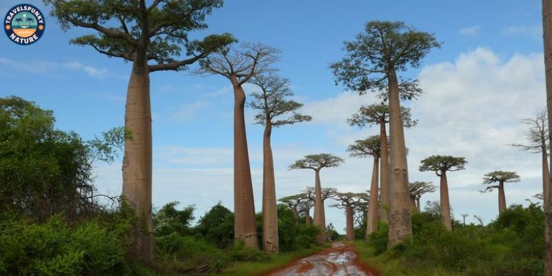
The Avenue of the Baobabs is the most photographed place in Madagascar, and it is not a park at all. It is a stretch of dirt road, about 260 m long, on the RN8 north of Morondava. Some 20 to 25 Grandidier’s baobabs line the track, smooth reddish grey columns up to about 30 m tall, the survivors of a forest cleared long ago, and the site is protected as a natural monument.
Almost everyone comes at sunrise or sunset. Sunset gives the strongest colour and the crowds. Sunrise is quieter and catches zebu carts and villagers on their way to work. Many pair the stop with a night walk in the Kirindy Reserve nearby, where the fossa hunts after dark.
Cost: There is no national park ticket here. Expect small local charges for parking and guiding, in cash, and agree them before you start.
How to reach it: The avenue is about 20 km northeast of Morondava, roughly 40 to 45 minutes on a rough unpaved road. Morondava is about an hour by air from the capital.
The honest downside: It is a short stop, not a day out, and sunset in the July to September peak can feel crowded. The ages quoted for the trees, often 800 years or more, are guesses, because baobabs lay down no reliable growth rings to count.
2. Tsingy de Bemaraha
In the west, rain has cut a limestone plateau into the largest forest of stone pinnacles on earth. The Tsingy de Bemaraha covers about 152,000 hectares, and UNESCO listed it in 1990. The pinnacles rise up to about 100 m, and the way through them is on foot, with a park guide.
The Grand Tsingy is the main event. Its circuits run for about four to six hours, climbing fixed ladders, crossing suspension bridges and clipping onto cables in a harness. The Petit Tsingy is gentler, about two hours at ground level with no harness. A pirogue trip along the Manambolo River gorge, under cliffs of about 100 m and past old Vazimba tombs in the rock, fills a second day.
Cost: Entry sits in the big park band, about 90,000 to 130,000 Ar a day for a foreign adult under the November 2026 scale, plus the guide fee and a small harness charge, all in cash at the park office.
How to reach it: The gateway village is Bekopaka, about 200 km north of Morondava. The drive takes six to ten hours in a 4×4, with ferry crossings on the Tsiribihina and Manambolo rivers.
The honest downside: This is dry season travel only. From about December to March the track floods, the ferries stop and the park is closed in all but name. The Grand Tsingy also needs a head for heights and a reasonable level of fitness.
3. Andasibe, Analamazaotra and Mantadia
Andasibe is the rainforest most visitors see, because it is the closest to the capital. Analamazaotra, the old Périnet reserve, is small, under 900 hectares, and holds habituated families of the indri, the largest living lemur. Mantadia, 15 to 20 km further north on a rough track, is far bigger and wilder, with waterfalls, diademed sifakas and black and white ruffed lemurs.
The indri is the reason to come. It is black and white, almost tailless, and it cannot survive in captivity, so this forest is the only place on earth to see one. Family groups sing in the morning, a wailing chorus that carries for about 2 km, and 14 lemur species have been recorded across the two parks. After dark, guided night walks run in the community and private reserves around the village, looking for mouse lemurs and chameleons.
Cost: Entry costs about 90,000 Ar a day for a foreign adult under the November 2026 scale, plus the guide fee, paid in cash at the park office.
How to reach it: Andasibe village is about 140 km east of Antananarivo on the paved RN2, a drive of three to four hours.
The honest downside: Analamazaotra is popular, and the main trails can feel busy in the peak months. It is also a wet forest in every season, so the trails are steep and slippery after rain.
4. Ranomafana National Park
Ranomafana protects about 41,600 hectares of steep, misty rainforest in the southeast, and it was created after the golden bamboo lemur was discovered here in 1986. Greater bamboo lemurs and Milne-Edwards’s sifakas live here too, among 14 lemur species in total. The park is part of the Rainforests of the Atsinanana World Heritage Site, which UNESCO removed from its danger list in July 2025.
The walking is the real thing, on steep forest trails with guides who know where each group feeds. Night walks along the road at the park edge are among the best in the country for mouse lemurs, chameleons and frogs. The ValBio research centre sits by the entrance.
Cost: Entry costs about 110,000 Ar a day for a foreign adult under the November 2026 scale, plus a small municipal tax and the guide fee. Bring cash, because there is no ATM in the village.
How to reach it: The park is a side trip east off the RN7, about 65 km beyond Fianarantsoa. From Antananarivo the drive is about 410 to 430 km and takes ten to twelve hours, so almost everyone breaks it with a night in Antsirabe or Ambositra.
The honest downside: This is the wettest park in the guide. Rain can arrive in any month, the trails are steep, and the long drive means Ranomafana needs at least two nights to make sense.
5. Isalo National Park
Isalo is a massif of Jurassic sandstone in the southwest, about 81,500 hectares of ridges, canyons and grassland beside the RN7. The gateway town is Ranohira, where the park office assigns guides and collects fees. The massif is sacred ground for the Bara people, whose burial places sit in the cliff walls.
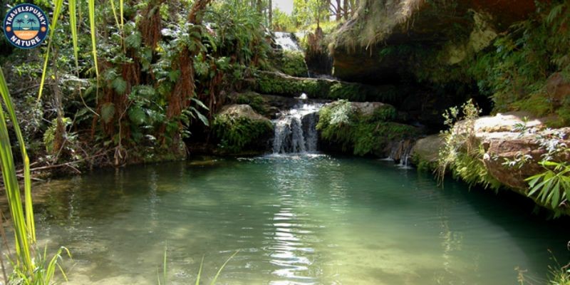
The classic walk crosses open plateau to the Piscine Naturelle, a clear pool under a small waterfall, ringed by palms, where swimming is allowed. The Namaza Canyon leads to more pools and the Cascade des Nymphes, and the Canyon des Makis is where ring tailed lemurs and Verreaux’s sifakas are most often seen. Most people also stop at the Window of Isalo, a natural rock arch beside the road that frames the sunset.
Cost: Entry costs about 130,000 Ar a day for a foreign adult under the November 2026 scale, the highest in this guide, plus the guide fee, paid in cash.
How to reach it: Ranohira is about 700 km south of Antananarivo on the RN7 and about 240 km northeast of Toliara. It is a stop on the drive south, not a day trip from anywhere.
The honest downside: The plateau has almost no shade, and the middle of the day is fierce in the hot months. Start walks early, and carry more water than you think you need.
6. Anja Community Reserve
Anja is the smallest sight in this guide and one of the most rewarding. It is a community reserve of about 30 hectares at the foot of three granite domes called the Three Sisters, just south of Ambalavao on the RN7. Local families formed the Anja Miray Association in 1999 and opened the reserve in 2001, and the village still runs it today.
The draw is the ring tailed lemurs. Anja holds the densest population of them in Madagascar, several hundred animals in family troops among the boulders, used to people without being fed. A short circuit takes about an hour, and longer walks climb toward the domes and pass traditional Betsileo tombs in the caves.
Cost: The reserve sets its own modest entry and guide fees, separate from the national park system, and they are paid in cash at the gate.
How to reach it: Anja sits directly on the RN7, about 12 km south of Ambalavao, and most drivers on the southern route stop for an hour or two on the way past.
The honest downside: Anja is a short stop, not a park day, and it cannot carry an itinerary on its own. Its value is as the easiest lemur sighting on the southern route.
7. The Rova and Ambohimanga, the royal hills of the capital
Two royal sites stand over Antananarivo, and they pair into one half day. The Rova is the palace complex on Analamanga Hill, the highest point of the city, crowned by the stone Queen’s Palace of Manjakamiadana. It was the home of the sovereigns of the Merina kingdom, and then of Madagascar, through the 17th, 18th and 19th centuries. On the night of 6 November 1995, a fire destroyed or damaged every structure in the complex, days before it was expected to join the UNESCO World Heritage list. Reconstruction took decades, and the complex reopened to visitors in 2023, with work continuing since.
The Royal Hill of Ambohimanga, roughly 20 to 24 km northeast of the city, is the quieter and more sacred of the two, and UNESCO listed it in 2001. It was the ancestral base of King Andrianampoinimerina, who ruled from 1787 to 1810 and united much of the island from here. Behind its walls stand his modest wooden house, royal summer homes, tombs and sacred places in a protected forest, and it is still a place of pilgrimage.
Cost: Both sites charge entry in ariary at local rates far below the national parks, with a basic Rova circuit reported at about 20,000 Ar. Confirm prices on the day.
How to reach it: The Rova stands in the upper town of Antananarivo, and Ambohimanga is about an hour’s drive northeast in city traffic.
The honest downside: Much of the Rova is reconstruction, and parts can be closed while work continues. Ambohimanga is about history and meaning rather than spectacle, and it only comes alive through the guide’s storytelling.
8. Nosy Be and Lokobe Reserve
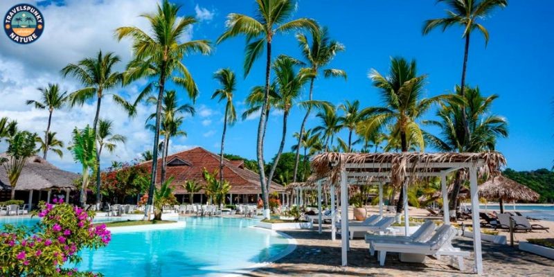
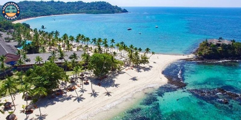
Nosy Be is the island off the northwest coast where most beach holidays in Madagascar happen. It has the country’s main resort strip and its own airport at Fascene. Its best known beach is Andilana, in the northwest of the island, but the landmark here is a forest.
The Lokobe Reserve protects about 740 hectares of forest, the last primary forest on Nosy Be, on the island’s southeast side. It was a research reserve for years and opened to visitors in 2014. The visit starts with a pirogue ride of about 40 minutes from the fishing village of Ampasipohy, then a guided walk under the canopy. Black lemurs are the headline species, the males black and the females rust coloured, along with panther chameleons, leaf tailed geckos and tiny Brookesia chameleons.
Cost: Lokobe entry sits in the national park band, about 90,000 to 130,000 Ar a day for a foreign adult under the November 2026 scale, and most visitors come on a hotel day trip that bundles the boat, the guide and lunch.
How to reach it: Fly from Antananarivo to Fascene Airport on Nosy Be, a flight of about one and three quarter hours, then travel by road and pirogue to the reserve.
The honest downside: Nosy Be is the most developed and most expensive corner of Madagascar, and its beaches, while pretty, are not the empty postcards of the brochures. The forest at Lokobe is the real reason to come.
9. Ifaty and the Spiny Forest
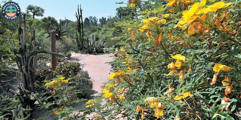
North of Toliara, at the end of the RN7, the fishing villages of Ifaty and Mangily face a lagoon sheltered by a coral reef. This is the beach end of the southern route. A few minutes inland stands the strangest forest in this guide.
The spiny forest grows only in the dry south and southwest. At the Reniala Reserve, a private reserve of about 60 hectares at the edge of Mangily, guided paths run through octopus trees, thorny thickets and bottle shaped baobabs of the species Adansonia rubrostipa. Reniala means mother of the forest, the local name for the baobab. Radiated tortoises, day geckos and endemic birds live among the spines.
Cost: Reniala sets its own entry by the length of the walk, and it is a small fee next to the national parks. The beach hotels can arrange the visit and the short transfer.
How to reach it: Ifaty and Mangily are about 25 to 30 km north of Toliara on a paved coast road, about 30 to 45 minutes by car. Toliara is the end of the RN7 and has flights back to the capital.
The honest downside: The spiny forest is an acquired taste, grey and thorny at first sight, and it gives up its wildlife slowly. Give it a guided early morning walk rather than a midday stroll.
10. The Red Tsingy and Montagne d’Ambre
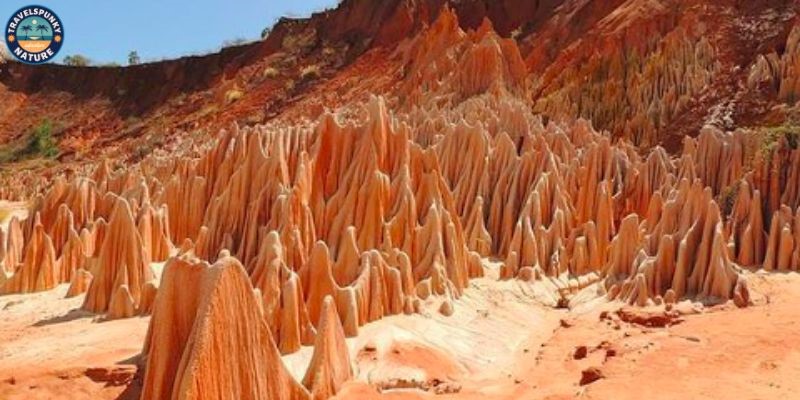
The north has two very different sights, and most visitors pair them from Antsiranana, also called Diego Suarez. The Red Tsingy is a canyon south of the city, where the Irodo River has carved soft laterite into thousands of pinnacles in red, ochre and cream. Unlike the grey limestone of Bemaraha, this formation is still changing, and the shapes shift after every rainy season. Visitors walk the rim paths and viewpoints for about one and a half to two hours, and the fragile formations are for looking and photographing, never climbing.
Montagne d’Ambre, the Amber Mountain, is the opposite, a block of cool mid altitude rainforest rising above the dry north, and one of the lushest forests in Madagascar. Its gateway is the hill town of Joffreville, about 45 minutes to an hour south of the city, and guided walks there find lemurs, chameleons and birds that the dry lowlands never see.
Cost: The Red Tsingy is run locally and charges a modest local entry, usually inside a full day 4×4 excursion price. Montagne d’Ambre sits in the national park band, about 90,000 to 130,000 Ar a day, plus the guide fee.
How to reach it: The Red Tsingy turn off is on the RN6 roughly 60 to 70 km south of Antsiranana, followed by about an hour of rough track, and a high clearance 4×4 is needed even in the dry months.
The honest downside: Both sights ask a lot of rough driving for compact visits, and the Red Tsingy track can become impassable in the wettest months, when excursions are cancelled.
Best time to visit Madagascar’s landmarks
The dry season runs from about April or May to November, and it is the working season for almost everything in this guide. Roads are at their best, the eastern rainforests are at their driest, and it is the only time the Tsingy de Bemaraha is open at all. July to September is the peak, with the most reliable weather and the biggest crowds.
The wet season runs from about December to March, inside the wider cyclone season of November to April. Heavy rain closes the west and washes out secondary roads, although Andasibe, the capital’s sights and Nosy Be can still be visited with flexible plans. If one window has to be named, choose May and June or September and October.
How to reach Madagascar, and getting around
Almost every trip starts at Ivato International Airport in Antananarivo, and most itineraries mix road, air and taxi-brousse from there.
By road, with a driver: The normal way to travel is a hired car with a driver, charged by the day. A good day on a main road averages about 40 km an hour. The RN7, the great southern route, runs about 950 km from Antananarivo to Toliara through Antsirabe, Fianarantsoa and Ambalavao, passing the turn offs for Ranomafana and Anja and ending within reach of Isalo and Ifaty. Allow the better part of a week for it with stops, and fly back from Toliara. A 4×4 is essential for the west and the northern tracks.
By air: Tsaradia, the domestic carrier of the national airline group, links Antananarivo with Nosy Be, Antsiranana, Morondava, Toliara and other regional airports, and Madagascar Airlines also flies some domestic routes. Flights save whole days, Toliara to the capital takes about an hour and a quarter, but schedules are thin and delays are common. Book flights first, and never put a domestic flight on the same day as an international departure.
By taxi-brousse: The shared minibuses called taxi-brousse connect every town, leave when full and cost a fraction of private hire. They work on the main paved routes, but they are slow and do not solve the last stretch to a park gate.
Park fees and guides: In the national parks, a local guide is compulsory and is paid separately from entry, per group and by circuit. Entry fees roughly doubled on 1 November 2026, to about 90,000 to 130,000 Ar a day for a foreign adult depending on the park. Park offices take cash in ariary only, with no card machines and no online booking, so draw money in the towns and confirm the tariff at each office.
Money and health: The currency is the ariary, written as Ar. Visa rules and fees change, so check the current position before you book. Malaria is present across the island, so talk to a doctor about preventive medicine before you travel.
Where to base yourself for each landmark
This table matches each base to the landmarks it covers best.
| No. | Base | Landmarks it covers | Good to know |
|---|---|---|---|
| 1 | Antananarivo | The Rova and Ambohimanga, and the start of every route | Give it a night at each end of the trip |
| 2 | Andasibe village | Analamazaotra and Mantadia | Two nights cover the indri, Mantadia and a night walk |
| 3 | Ranomafana village or Fianarantsoa | Ranomafana | The village sits by the park, and Fianarantsoa is the bigger town 65 km away |
| 4 | Ambalavao | Anja, on the RN7 south | A short stop town, and most visitors sleep one night |
| 5 | Ranohira | Isalo | The park office and the guides are in the town |
| 6 | Morondava | Avenue of the Baobabs, and the road to Bemaraha | Sleep here before and after the Tsingy drive |
| 7 | Toliara and Ifaty | Ifaty, the spiny forest and the end of the RN7 | Fly back to the capital from Toliara airport |
| 8 | Nosy Be | Lokobe and the island’s beaches | The resort base, reached by air from the capital |
| 9 | Antsiranana | The Red Tsingy and Montagne d’Ambre | The northern base, reached by air from the capital |
FAQs
1. What is the most famous landmark in Madagascar?
The Avenue of the Baobabs. Nothing else on earth looks like it, a dirt road lined with giant baobabs up to about 30 m tall, and at sunset it is the most photographed scene in the country.
2. How much do Madagascar’s national parks cost in 2026?
Since 1 November 2026, a foreign adult pays about 90,000 to 130,000 Ar per day depending on the park, roughly double the old scale. A local guide is compulsory on top, paid per group and by circuit, and park offices take cash only.
3. How many days do you need for these landmarks?
About two weeks covers Andasibe and the RN7 south to Toliara at a sane pace. The west, Morondava and the Tsingy de Bemaraha, adds four to five days, and the north adds three to four more. Doing all three regions in under two weeks means spending most of the trip in a car.
4. When can you visit the Tsingy de Bemaraha?
Only in the dry season, in practice from about mid April or May to November. In the wet months the access track floods, the ferries stop and the park is closed in all but name.
5. Where is the best place to see lemurs in Madagascar?
It depends on the lemur. Andasibe is the place for the indri and its morning song, Ranomafana gives the widest variety in deep rainforest, and Anja gives ring tailed lemurs at close range.
6. Is it safe to travel in Madagascar in 2026?
Read the travel conditions note near the top of this guide. As it was researched in November 2026, the United Kingdom did not advise against travel and the United States rated the country Level 2, exercise increased caution. Travel by day and avoid gatherings.
Researched and verified: November 2026. This guide is research-based, compiled from official visitor information, maps and traveller reports. Prices, hours and road conditions change, so confirm them locally before travelling.